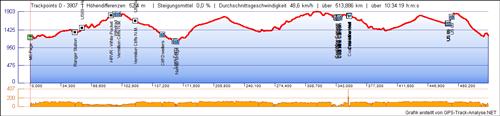
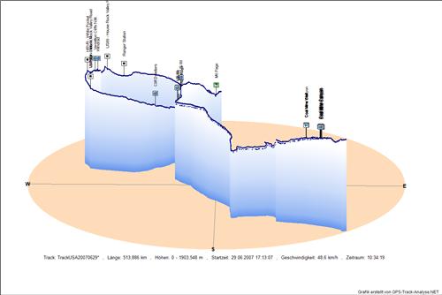
Track: USA20070629
M6 Page - Ranger Station - US89 - House Rock Valley Road - HRVR - White Pocket - Windrad - Vermillion Cliffs N.M. - Vermilion Cliffs N.M. - US89alt - House Rock Valley Road - Cliff Dwellers - Lees Ferry - Navajo Bridge - Coal Mine Canyon - Coal Mine Canyon - Coal Mine Canyon - Coal Mine Canyon - Coal Mine Canyon - Coal Mine Canyon - Coal Mine Well - Coal Mine Canyon - Coal Mine Well - Coal Mine Well - US 89 - US 89 - US 89
Aufgezeichnet am
Streckenlänge
Minimale Höhe
Maximale Höhe
Zeitraum incl. Pausen29.06.2007 17:13:07
513,886 km
1090,8 m
1903,5 m
10,57 h2D Höhenmodell
3D Höhenmodell
Downloads:
GPX - Datei gezipt
KMZ - Archiv für GoogleEarth
2D Höhenmodell in Originalgröße
3D Höhenmodell in Originalgröße